sandywp / plugins / wp-gpx-maps

WP GPX Maps
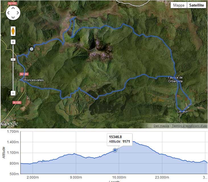
Draws a GPX track with altitude graph. You can also display your nextgen gallery images in the map.
Ready in seconds.
v1.7.11 4,000+ installs WP 6.2.0+
What you get inside
6 screens-
Simple GPX
-
GPX with waypoints
-
Admin area - List of tracks
-
Admin area - Settings
-
Altitude & Speed
-
Altitude & Speed & Heart rate
About this plugin
This plugin has, as input, the GPX file with the track you’ve made and as output it shows the map of the track and an interactive altitude graph (where available).
Fully configurable:
- Custom colors
- Custom icons
- Multiple language support
Supported charts:
- Altitude
- Speed
- Heart rate
- Temperature
- Cadence
- Grade
NextGen Gallery Integration:
Display your NextGen Gallery images inside the map!
Even if you don’t have a GPS camera, this plugin can retrive the image position starting from the image date and your GPX file.
Post Attachments Integration:
This version is extended by: Stephan Klein and supports displaying all images attached to a post without using NGG.
Try this plugin: https://devfarm.it/wp-gpx-maps-demo/
Support:
If you need help, please use: www.devfarm.it Support Forum
Would you like to help fix bugs or further develop the plugin? On Github you can contribuite easly with your code.
Translations:
Translators are welcome to contribute to the plugin. Please use the WordPress translation website.
The language files in the plugin contain 18 translatable texts for 13 languages:
- Catalan ca
- Dutch nl_NL
- English (default)
- French fr_FR
- Hungarian hu_HU
- Italian it_IT
- Norwegian nb_NO
- Polish pl_PL
- Portuguese (Brazilian) pt_BR
- Russian ru_RU
- Spanish es_ES
- Swedish sv_SE
- Turkish tr_TR
- Bulgarian bg_BG
- Slovak cs_CZ
- Norwegian nb_NO
- Japanese ja_JP
(Many thanks to all guys who helped me with the translations)
Supported GPX namespaces are:
-
http://www.topografix.com/GPX/1/0
-
http://www.garmin.com/xmlschemas/GpxExtensions/v3
-
http://www.garmin.com/xmlschemas/TrackPointExtension/v1
Thanks to: www.securcube.net, www.devfarm.it
Icons made by Freepik from www.flaticon.com is licensed by Creative Commons BY 3.0
Questions
- Which map types are available?
You can use the following map types:
- OSM1 = Open Street Map (Default setting)
- OSM2 = Open Cycle Map / Thunderforest – Open Cycle Map (API Key required)
- OSM3 = Thunderforest – Outdoors (API Key required)
- OSM4 = Thunderforest – Transport (API Key required)
- OSM5 = Thunderforest – Landscape (API Key required)
- OSM7 = Open Street Map – Humanitarian map style
- OSM9 = Hike & Bike
- OSM10 = Open Sea Map
If you use the OpenCycleMap without the API key, a watermark appears on the card: “API Key required”.
The Thunderforest maps Outdoors, Transport and Landscape are only displayed with an API Key.
- Which shortcode attributes are available?
You can use the following shortcodes:
- gpx: Relative path to the GPX file
- width: Map width (Value in percent)
- mheight: Map height (Value in pixeln)
- gheight: Graph height (Value in pixeln)
- skipcache: Do not use cache. If TRUE might be very slow (Default is false)
- download: Allow users to download your GPX file (Default is false)
- summary: Print summary details of your GPX track (Default is false)
- summarytotlen: Print total distance in summary table (Default is false)
- summarymaxele: Print max elevation in summary table (Default is false)
- summaryminele: Print min Elevation in summary table (Default is false)
- summaryeleup: Print total climbing in summary table (Default is false)
- summaryeledown: Print total descent in summary table (Default is false)
- summaryavgspeed: Print average Speed in summary table (Default is false)
- summarytotaltime: Print total time in summary table (Default is false)
- mtype: Map types
- mlinecolor: Map line color (Default is #3366cc)
- zoomonscrollwheel: Zoom on map when mouse scroll wheel (Default is false)
- waypoints: Print the gpx waypoints inside the map (Default is false)
- startIcon: Start track icon
- endIcon: End track icon
- currentIcon: Current position icon (when mouse hover)
- waypointicon: Custom waypoint icon
- showele: Show elevation data inside the chart (Default is true)
- uom: Distance/altitude unit of measure
- 0 = meters/meters (Default setting)
- 1 = feet/miles
- 2 = meters/kilometers
- 3 = meters/nautical miles
- 4 = meters/miles
- 5 = feet/nautical miles
- glinecolor: Altitude line color (Default is #3366cc)
- chartFrom1: Minimun value for altitude chart
- chartTo1: Maxumin value for altitude chart
- showspeed: Show speed inside the chart (Default is false)
- glinecolorspeed: Speed line color (Default is #ff0000)
- uomspeed: Unit of measure for speed
- 0 = m/s (Default setting)
- 1 = km/h
- 2 = miles/h
- 3 = min/km
- 4 = min/miles
- 5 = Nautical Miles/Hour (Knots)
- 6 = min/100 meters
- chartFrom2: Minimun value for speed chart
- chartTo2: Maxumin value for speed chart
- showhr: Show heart rate inside the chart (Default is false)
- glinecolorhr: Heart rate line color (Default is #ff77bd)
- showatemp: Show temperature inside the chart (Default is false)
- glinecoloratemp: Temperature line color (Default is #ff77bd)
- showcad: Show cadence inside the chart (Default is false)
- glinecolorcad: Cadence line color (Default is #beecff)
- showgrade: Show grade inside the chart (Default is false)
- glinecolorgrade: Grade line color (Default is #beecff)
- nggalleries: NextGen Gallery id or a list of Galleries id separated by a comma
- ngimages: NextGen Image id or a list of Images id separated by a comma
- attachments: Show all images that are attached to post (Default is false)
- dtoffset: The difference (in seconds) between your gpx tool date and your camera date
- pointsoffset: Skip points closer than XX meters (Default is 10)
- donotreducegpx: Print all the point without reduce it (Default is false)
- What happening if I’ve a very large GPX files?
This plugin will print a small amout of points to speedup javascript and pageload.
- Is it free?
Yes!
sandywp / also on the shelf
Try another plugin

wpDataTables – WordPress Data Table, Dynamic Tables & Table Charts Plugin
4.5 · 70K+ installs
The best WordPress table plugin. Create responsive, and searchable tables and charts from Excel (.xlsx, .xls or .ods), CSV, XML,…

4.1 · 10K+ installs
Pricing Table generator by Supsystic allows you to create responsive pricing tables or comparison table without any programming…

Chartify – WordPress Chart Plugin
4.9 · 3K+ installs
Chartify is a powerful WordPress Chart Builder Plugin that will help you to create WordPress Graphs & Charts easily and…
Spin up a real WordPress site in seconds.
Test plugins, build a demo, hand a client a link — then squash it and start again. No local setup, no Docker.